Accurate wind
measurement
at sea
measurement
at sea
INNOVATIVE TECHNOLOGY
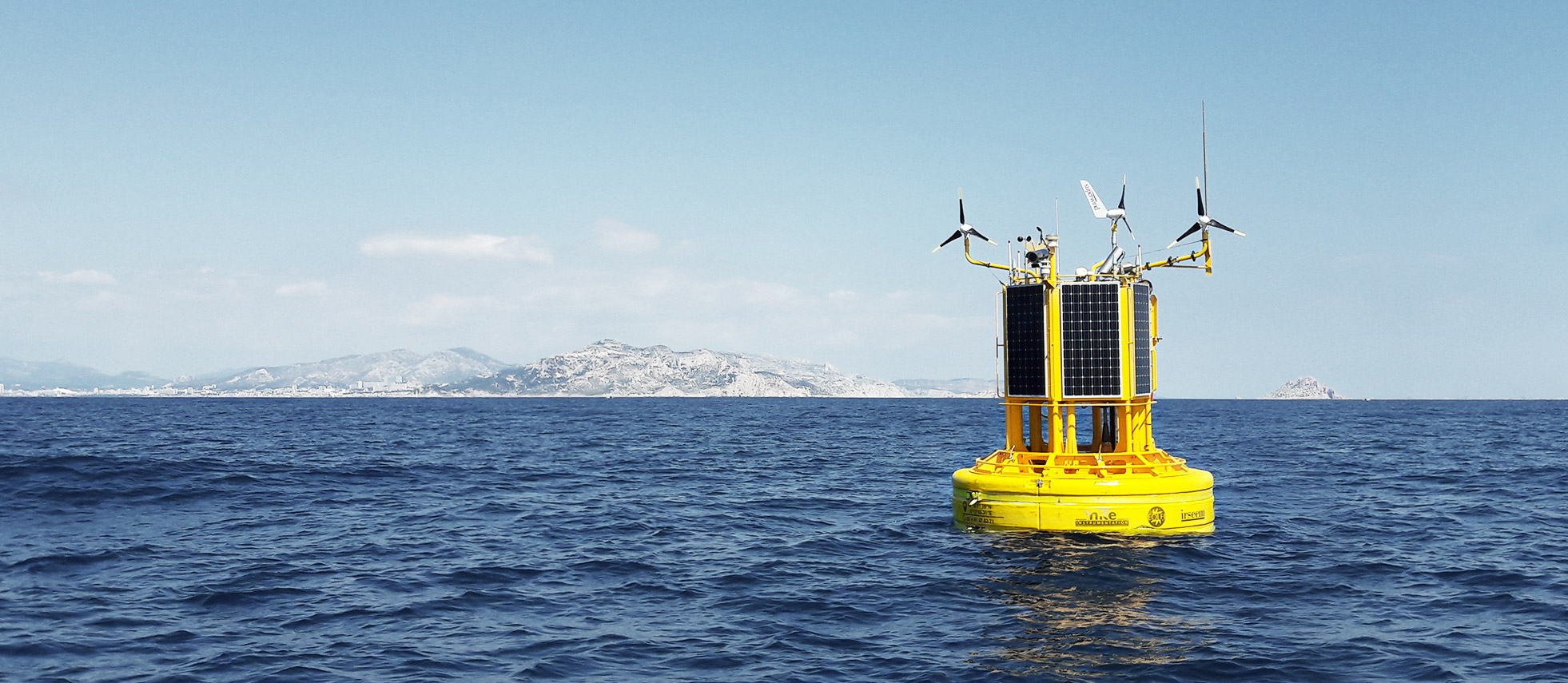
Based on more than 2 years of R&D, the Accurasea buoy provides high-level reliable meteocean mesurements thanks to its stand-alone and robust design.
CHARACTERISTICS
ACCURATE
Accurasea’s main mission is to measure wind with the highest accuracy possible in all weather and ocean conditions that can be encountered on an offshore wind farm to reduce the resource assessment uncertainty.
DESIGNED IN FRANCE
Accurasea is the result of a collaborative R&D project combining the skills and expertise of two French SMEs and two French research institutes.
EASY TO TRANSPORT
Accurasea has been designed to be transported in standard containers which simplifies its shipment to all continents by boat or truck.
FULLY EQUIPED
Accurasea measures wind, wave and currents parameters as well as a wide range of physical data from the marine environment.
SCALABLE
Accurasea’s design includes a standard central part and various appendices that adapts its hydrodynamic behaviour to a specific site or region of the globe.
COMPATIBLE
Accurasea can carry several LiDARs from the market, such as the Windcube V2 from Leosphere or the Diabrezza from Mitsubishi Electric.
CARBON TRUST TYPE VALIDATION
Floating LiDARs have the potential to replace meteorological measurement masts in the measurement of key wind data – speed and direction – at a fraction of their cost.
DNV GL has independently validated the Accurasea floating LiDAR offshore wind measurement device and reached the 2nd stage of the Carbon Trust Offshore Wind Accelerator Roadmap. Data and system availability/reliability and accuracy have reached the best acceptance criteria. Accurasea can therefore be used commercially for the Wind Ressource Assessment (WRA) of offshore wind farm projects.

Carbon Trust has established a Roadmap for Commercial Acceptance of Floating LiDAR. The roadmap criteria focus on the overall/monthly system and post-processed data availability, reliability and wind speed & direction accuracy.
CARBON TRUST VALIDATION
Floating LiDARs have the potential to replace meteorological measurement masts in the measurement of key wind data – speed and direction – at a fraction of their cost.
DNV GL has independently validated the Accurasea floating LiDAR offshore wind measurement device and reached the 2nd stage of the Carbon Trust Offshore Wind Accelerator Roadmap. Data and system availability/reliability and accuracy have reached the best acceptance criteria. Accurasea can therefore be used commercially for the Wind Ressource Assessment (WRA) of offshore wind farm projects.
Carbon Trust has established a Roadmap for Commercial Acceptance of Floating LiDAR. The roadmap criteria focus on the overall/monthly system and post-processed data availability, reliability and wind speed & direction accuracy.
HISTORIC
Objectives
BLIDAR was the R&D collaborative project that led to the development of the Accurasea buoy. It has won the FUI tender 11. Its objective was to develop a meteo-oceanographic buoy to assess the wind resource on a specific site with the lowest uncertainty possible in order to quantify the energy production of offshore wind farms.
Characteristics
Duration : 2.5 years (2014-2016)
Budget : €2.2 million
Project Labelling


R&D campaign
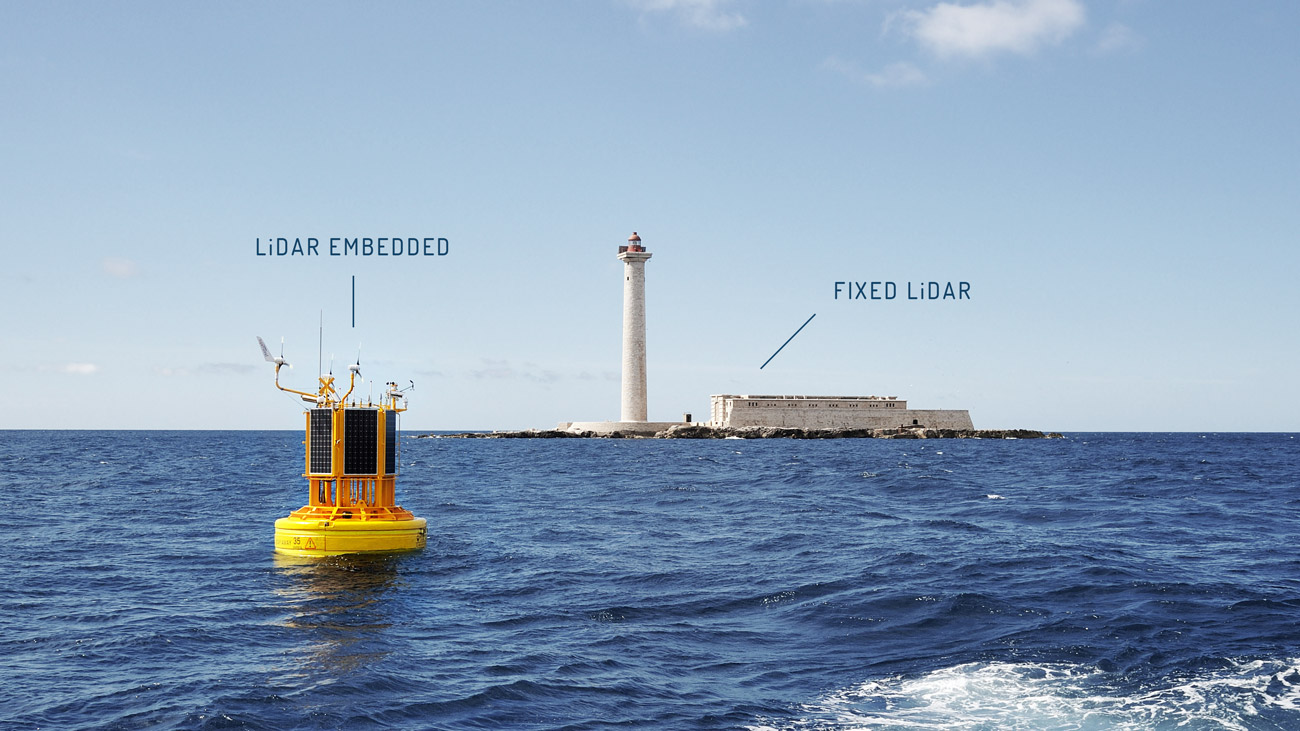
The 17 months campaign in Le Planier, close to Marseilles (France), validated in particular :
- The accuracy of wind measurements, through the comparison of measurements between the LiDAR carried on the buoy and the fixed LiDAR located in Le Planier island
- The accuracy of the meteocean parameters, through comparison of measurements with a nearby second buoy
- A complete follow-up and optimization of the operational aspects related to the deployment of such an instrumented buoy: transport, availability, maintenance, safety

HISTORIC
Objectives
BLIDAR was the R&D collaborative project that led to the development of the Accurasea buoy. It has won the FUI tender 11. Its objective was to develop a meteo-oceanographic buoy to assess the wind resource on a specific site with the lowest uncertainty possible in order to quantify the energy production of offshore wind farms.
Characteristics
Duration : 2.5 years (2014-2016)
Budget : €2.2 million
R&D campaign
The 17 months campaign in Le Planier, close to Marseilles (FR), validated in particular :
- The accuracy of wind measurements, through the comparison of measurements between the LiDAR carried on the buoy and the fixed LiDAR located in Le Planier island
- The accuracy of the meteocean parameters, through comparison of measurements with a nearby second buoy
- A complete follow-up and optimization of the operational aspects related to the deployment of such an instrumented buoy: transport, availability, maintenance, safety
Project Labelling
CONTACT
Accurasea processes your personal data as the Data Controller in order to be able to fulfil your requirements. All information requested with a * is mandatory in order to be able to process your request. You have the right of access, rectification, erasure and portability of your personal data, a right to restrict the processing of your personal data as well as a right to define the parameters of your digital heritage. You may exercise all these rights by writing to info@accurasea.com Please consult our Personal Data Information Notice for more information.